A few years ago, the idea of a drone buzzing over your roof during a property survey would have seemed far-fetched. Today, it's becoming increasingly common — and for good reason. Drone technology has matured rapidly, and forward-thinking surveyors are already using it as a powerful tool in their inspection toolkit.
But does a drone survey replace the need for a traditional building survey? Can it catch everything a surveyor walking through a property would find? As someone who has used drone inspection technology alongside conventional surveying methods across Wolverhampton and the West Midlands, I want to give you an honest, balanced answer.
1. What Is a Drone Property Survey?
A drone property survey uses an Unmanned Aerial Vehicle (UAV) equipped with a high-resolution camera to capture detailed imagery of parts of a building that are difficult or impossible to inspect safely from the ground. This typically means roofs, chimney stacks, high-level elevations, and flat roof sections.
The drone operator flies the drone around and over the property, capturing still images and video footage. The surveyor then reviews this footage and incorporates findings into their written report — adding a layer of visual evidence that a ground-level inspection simply cannot match for inaccessible areas.
Regulatory note: In the UK, commercial drone operations require a CAA Operational Authorisation. Always check that your surveyor or drone operator is properly licensed before work begins — ask to see their credentials.
2. What Can Drones Detect?
When used correctly, drones are genuinely impressive for high-level visual inspection. A skilled operator with a quality camera drone can identify:
Roof tile defects
Missing, cracked, slipped, or broken tiles — often more clearly visible from above than from ground level, especially on complex roof shapes.
Damaged flashings
Lead or felt flashings around chimneys, valleys, and flat roof perimeters are a frequent source of water ingress. Drones capture close-up imagery to assess their condition accurately.
Chimney stack deterioration
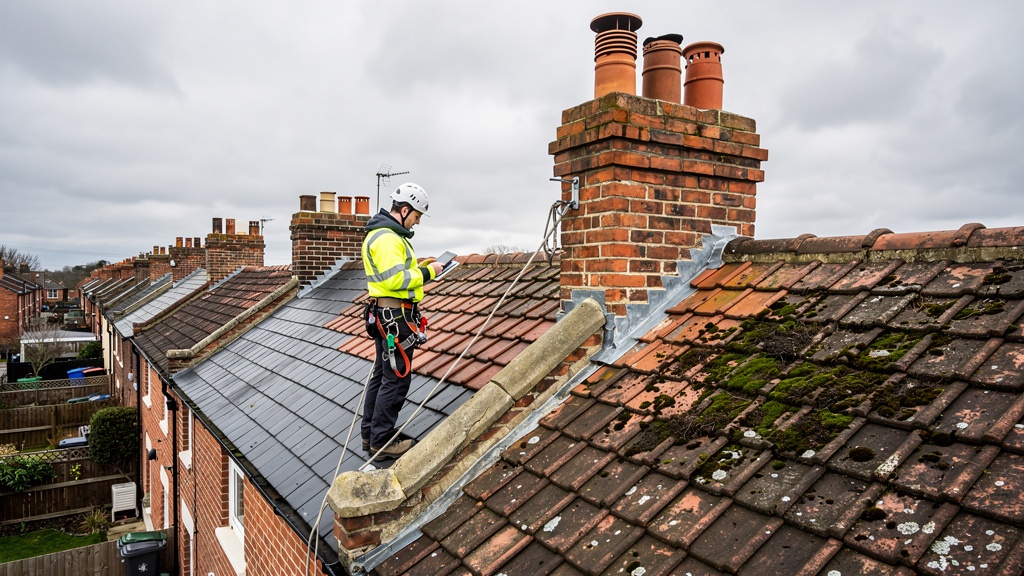
Crumbling mortar joints, cracked pots, and spalling brickwork — a major finding in Wolverhampton's older housing stock, and drones make inspection safe and quick.
Blocked or damaged guttering
Overflowing or sagging gutters, vegetation growth, and fascia board damage are easy to assess from aerial footage before water damage occurs.
Moss and vegetation growth
Significant moss on roofs indicates moisture retention and may accelerate tile deterioration. Often invisible from the street but very obvious from above.
Ridge and hip condition
Deteriorating ridge tiles and bedding mortar are extremely common on properties over 30 years old. Drones provide a much clearer view than binoculars from ground level.
3. What Drones Cannot Do
This is the critical part — and it's why a drone survey is a supplement to a building survey, never a replacement. Here's what no drone can do:
Inspect internal elements
A drone cannot enter the loft space to check for rafter damage, inadequate insulation, signs of water ingress at felt level, or structural issues invisible from outside. The interior is where many of the most significant findings hide.
Test for damp
Moisture meters, hygrometers, and physical probing of walls and floors are essential damp investigation tools. A drone sees surfaces only — it cannot measure moisture content or identify rising damp behind wall coverings.
Assess structural movement
Identifying whether wall cracks indicate subsidence, settlement, or just thermal movement requires a trained surveyor on the ground examining crack patterns, widths, and orientation — alongside ground conditions and site context.
Check services and installations
Electrical, plumbing, heating, and drainage systems all require physical inspection. A drone has no ability to test a boiler, check a consumer unit, or assess drainage gradients.
Operate in all weather conditions
Drones cannot fly safely in heavy rain, strong winds above around 25 mph, or dense fog. In Wolverhampton, where weather is unpredictable, this can limit their usefulness on any given survey day.
4. How We Use Drone Surveys in Wolverhampton
Wolverhampton's housing stock is dominated by Victorian and Edwardian terraces — many of which have steep-pitched roofs that are genuinely difficult to inspect safely without ladders or scaffolding. In these cases, drone inspection is particularly valuable.
When carrying out a Level 3 Building Survey on an older Wolverhampton property, we use drone footage to supplement our ground-level and loft-space inspections. This means we can provide clients with close-up imagery of chimney stack conditions, tile defects, and valley flashings that would otherwise require expensive scaffolding to see clearly.
Real example: On a recent Level 3 survey in Tettenhall, drone footage revealed that three ridge tiles had completely lost their bedding mortar on the rear elevation — invisible from ground level. The repair cost was factored into the client's price negotiation, saving them over £900.
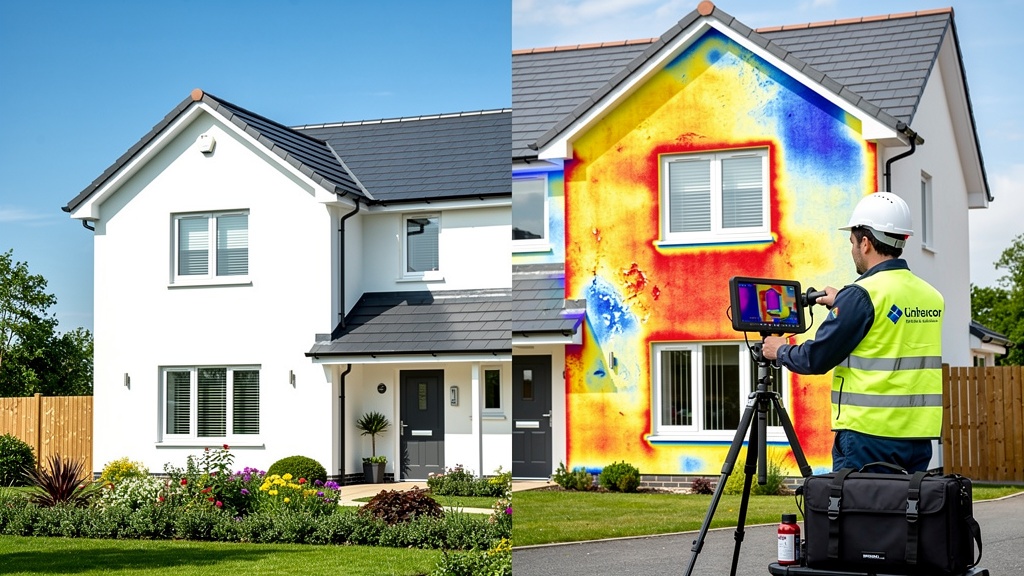
5. Thermal Imaging Drones: The Next Step
Standard camera drones capture visible-spectrum imagery. The next generation uses thermal (infrared) cameras to detect temperature variations across a building's surface — opening up significantly more diagnostic capability:
- Heat loss mapping: Areas of poor insulation show as "hot spots" on thermal imagery, identifying where a property is losing heat most severely.
- Moisture detection: Water absorbs and releases heat differently from dry materials. Thermal drones can sometimes identify moisture retention in flat roofs or walls not yet visible to the naked eye.
- Electrical hotspots: Overheating in electrical panels or wiring can appear on thermal imagery — though this requires careful interpretation by a qualified professional.
Thermal drone surveys are still relatively specialist and add cost to the inspection process. But as the technology becomes more accessible, expect them to feature more widely in standard building surveys within the next five years.
Worth knowing: For thermal imaging to be most effective, inspections should ideally take place early morning or after dark when temperature differentials between the building fabric and surrounding air are greatest. Overcast days also help by eliminating solar gain that can mask heat loss patterns.
6. How Much Does a Drone Survey Cost?
In the West Midlands, standalone drone roof surveys typically cost between £150 and £400, depending on property size and reporting level required.
Typical cost for a standalone drone roof survey in the West Midlands — usually far less than the cost of scaffolding for a traditional close-up roof inspection.
When drone inspection is incorporated into a full Level 3 Building Survey, the additional cost is usually modest — often absorbed within the overall survey fee. Compare this to the cost of erecting scaffolding for a traditional close-up roof inspection, which can easily reach £500–£1,500 for a standard terraced house, and the economics become very clear.
7. The Verdict: A Powerful Tool, Not a Replacement
Drone technology has genuinely changed what's possible in property inspection. It gives surveyors safer, faster access to high-level elements of a building and produces clear photographic evidence valuable for both reporting and negotiation.
But a drone survey alone is not a building survey. Think of it this way: a drone is to a building survey what an X-ray is to a full medical examination. It reveals things that would otherwise be invisible — but you still need the doctor to interpret what they mean and examine everything else.
The best approach? A comprehensive RICS Level 3 Building Survey with drone inspection incorporated for properties with inaccessible roofs or high-level elements. That combination gives you the fullest possible picture of a property's condition.
FAQs: Drone Property Surveys
No. A drone survey is a useful supplementary tool for inspecting roofs and high-level elevations, but it cannot replace a full RICS building survey. Drones cannot inspect internal elements, test for damp, assess structural movement, or check plumbing and electrical systems.
Standalone drone roof surveys typically cost between £150 and £400 in the UK, depending on property size and reporting level. When combined with a full building survey, the additional cost is usually modest — especially compared to the alternative cost of scaffolding.
Yes. Commercial drone operators in the UK must hold a CAA Operational Authorisation. Surveyors using drones should be GVC (General Visual Line of Sight Certificate) qualified or hold equivalent CAA authorisation. Always verify credentials before commissioning drone work.
A drone with a high-resolution camera can identify missing, cracked or slipped tiles, damaged flashings around chimneys and valleys, blocked or damaged guttering, deteriorating mortar on chimney stacks, and signs of moss or vegetation growth indicating moisture retention.
Yes, increasingly so — particularly for Victorian and Edwardian terraces where roof access would otherwise require scaffolding or a cherry picker. Drone inspection is a cost-effective way to carry out thorough high-level inspections on Wolverhampton's older housing stock.
Key Takeaways
- Drones provide safe, detailed inspection of roofs, chimneys, and high-level elevations
- They supplement — not replace — a full RICS building survey
- Typical standalone drone survey cost: £150–£400 in the West Midlands
- Thermal imaging drones offer additional capability for heat loss and moisture detection
- Commercial drone operators must hold CAA Operational Authorisation
- Particularly valuable for Wolverhampton's Victorian and Edwardian housing stock
- Drone findings can support price negotiations when roof defects are identified